
Units serve as guides to a particular content or subject area. Nested under units are lessons (in purple) and hands-on activities (in blue).
Note that not all lessons and activities will exist under a unit, and instead may exist as "standalone" curriculum.
| Unit | Lesson | Activity |

Continuing the Asteroid Impact challenge, students learn how to determine map distances and areas using map scales. They get a feel for how much an area represents on a map in relation to the sizes they are suggesting for their underground caverns to shelter the Alabraska population. This engineering curriculum aligns to Next Generation Science Standards (NGSS).
Many types of engineers—civil, geological, petroleum, environmental—must fully understand maps, map reading and map creation to assist in the research and planning of engineering design solutions, such as designing roadways and tunnels, drilling for water or fossil fuels, creating dams, and tracking air pollution.
After this activity, students should be able to:
Each TeachEngineering lesson or activity is correlated to one or more K-12 science, technology, engineering or math (STEM) educational standards.
All 100,000+ K-12 STEM standards covered in TeachEngineering are collected, maintained and packaged by the Achievement Standards Network (ASN), a project of D2L (www.achievementstandards.org).
In the ASN, standards are hierarchically structured: first by source; e.g., by state; within source by type; e.g., science or mathematics; within type by subtype, then by grade, etc.
MS-ESS2-2. Construct an explanation based on evidence for how geoscience processes have changed Earth's surface at varying time and spatial scales. (Grades 6 - 8)
Do you agree with this alignment? Thanks for your feedback!
Alignment agreement: Thanks for your feedback!
Alignment agreement: Thanks for your feedback!
Water's movements—both on the land and underground—cause weathering and erosion, which change the land's surface features and create underground formations.
Alignment agreement: Thanks for your feedback!
Alignment agreement: Thanks for your feedback!
Visit [ www.teachengineering.org/activities/view/csm_asteroid_lesson3_activity1_tg ] to print or download.
Some knowledge of length, width, area and volume; multiplication.
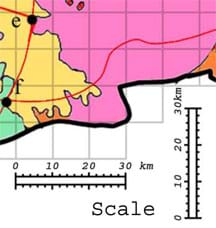
Now that your engineering team knows the required cavern area, your task is to translate that information to a map to see how big the cavern is compared to the size of the state of Alabraska.
As necessary, refresh students' knowledge on how to use map scales.
Before the Activity
With the Students
Q1: To put the worksheet answers into perspective, ask students to compare their answers to their own home-to-school distance.
Q2:The grid space area is determined by multiplying length by width.
Q3: Expect students to figure out that they can count grid spaces within the military base and multiply by the area per grid space (Q2 answer).
Q4: This is to give the students perspective.
Q5: Expect students to find that Alabraska is much bigger than the required cavern area.
Worksheet: Review students' answers on the Scaling the Map Worksheet to gauge their mastery of the subject matter. Refer to the Asteroid Impact Student Workbook Example Answers provided in the unit document for example worksheet answers.
Quiz: To conclude, ask students to estimate distances using a different map. For example, estimate the distance from two cities such as London and Moscow, or the area of a U.S. state. Or have students conduct the Extension Activities.
Homework: If students drew plans of their cavern designs at the end of the previous activity, now assign them re-draw them to scale. An appropriate scale is 1 cm = 1 km.
Get the inside scoop on all things TeachEngineering such as new site features, curriculum updates, video releases, and more by signing up for our newsletter!
PS: We do not share personal information or emails with anyone. Subscribe to TE Newsletter
Middle School Activity
Identifying Possible Underground Cavern LocationsStudents apply their knowledge of scales and areas to determine the best locations in Alabraska for the underground caverns. They cut out rectangular paper pieces to represent caverns to scale with the maps and place the cutouts on the maps to determine possible locations.

Middle School Activity
Incoming Asteroid! What's the Problem?To kickoff the Adventure Engineering Asteroid Impact unit, students learn of the impending asteroid impact scenario, form teams and begin to study the situation in depth. A simple in-class simulation shows them the potential for destruction and disaster. They look at maps and complete a worksheet an.

Middle School Unit
Adventure Engineering Challenge: Asteroid ImpactThrough this earth science curricular unit composed of eight activities, student teams are presented with the scenario that an asteroid will impact the Earth. In response, their challenge is to design the location and size of underground caverns to shelter the people from an uninhabitable Earth for .

Middle School Activity
Rocks, Rocks, Rocks: Test, Identify Properties & ClassifyStudents test rocks to identify and record their physical properties (such as luster, hardness, color, etc.) and classification (igneous, metamorphic or sedimentary). They complete a worksheet data table and questions.

Adventure Engineering was supported by National Science Foundation grant nos. DUE 9950660 and GK-12 0086457. However, these contents do not necessarily represent the policies of the National Science Foundation, and you should not assume endorsement by the federal government.
Last modified: April 3, 2018
Free K-12 standards-aligned STEM curriculum for educators everywhere.
Find more at TeachEngineering.org


Use of the TeachEngineering digital library and this website constitutes acceptance of our Terms of Use and Privacy Policy.
*The NGSS logo is a registered trademark of WestEd.
Neither WestEd nor the lead states and partners that developed the NGSS were
involved in the production of TE, and do not endorse it.